Saturday, February 28, 2015

ARNOLDUS ASSELBERGSSTRAAT


This street belongs to the green part of the ring around the medieaval town. It is named after one of the first industrial entrepreneurs. Arnoldus Asselbergs (1811-1880) started a forge in 1841, together with his partner Janus van der Hoeven. Little by little this modest facility became an iron foundry, which employed many workers.

The street has two 'arms'. In between is a little public garden called Bevrijdingsplantsoen (Liberation Green). A statue by Nicolaas van der Kreek (1896-1967) reminds the passer-by of the Liberation of Bergen op Zoom by Canadian forces on October 27th 1944. It was established in 1955.


Nicolaas van der Kreek was born in Bergen op Zoom and died in Bussum. He was active in more artistic fields but made a name as a sculptor. As such he was a member of several societies a.o. 'Arti et Amicitiae' and 'De Onafhankelijken' (The Independant Ones) in Amsterdam. In 1923 he was awarded a silver medal in the Prix de Rome-contest.


The monument, dedicated to all the people who died in the war, was unveiled by Piet van Gils. He was the son of a resistance fighter who didn't live to enjoy the liberation.


A ceramic statuette above the door of number 37.


The decoration of number 6. The house is called 't Hoekje ('The little corner'), since it is situated on the spot where Arnoldus Asselbergsstraat and Williamstraat meet.


www.alberthagenaars.nl


Saturday, January 31, 2015

KIJK IN DE POT

An area where human activities took place as far back in time as the Iron Age and the Roman Era, Kijk in de Pot is now a park of 20 ha, located between the historic centre and Lake Binnenschelde (Inner Scheldt).
The name (meaning 'A view into the pot' or 'Looking into the pot') originates from an early 17th century redoubt (redoute in French), which offered a splendid view on the area. Many modifications in the defense system followed.

The municipality of Bergen op Zoom managed to buy the grounds in 1979 and decided to transform them into a park, designed by Pieter Germeraad, some twenty years later.
Several artists participated in the decoration of the park, which remained an open space after a part in the northwest became a residential area with names reflecting the former military functions in this part of town such as Escarp, Saillant, Coupure, Poterne and, of course, Redoute.


A modern interpretation of the former fortifications by artists Auke van der Heide and Jan Wessendorp. All photos: © Albert Hagenaars, December 2014.


A view on the Slikschans (Mud flat sconce) or Veldschans (Field sconce), also a design by Auke van der Heide and Jan Wessendorp, based upon a similarly shaped fortress on this spot. They commissioned poetry for the walls from author Albert Hagenaars, who shared the assignment with his colleague Bert Bevers. They realized two poems together, meaning they came up with mixed texts. Each word by one was followed by a word by the other.


The main text reads:

Jij die hier verdwijnt
doorzie dit niemandsland vol iedereen


Translated:

You who vanish here
see through this no man's land full with everybody
.

These lines reflect centuries of military action, many victims. So, one could also read: every body in the sense of corpse.


A detail from the second poem:

door tij & tijd bestendigt
deze verschansing woorden
die zich niet laten kennen:
strijd roert ons tot wie we zijn
in de dunte der dagen
.

became:

through tide & time
this entrenchment perpetuates words
that refuse to speak:
struggle moves us until we are who we are
in the thinness of the days
.


A sculpture with three crabs (1980) by Kees Keijzer (1927, Heerle - 1990, Wouw) who studied at the academy of arts St Joost in Breda. This monument was originally placed in front of the civic centre at the corner of Sint Annastraat and Kortemeestraat, which was replaced by an apartment building including shops.
Keijzer specialized in working with iron. His sculptures can be seen in several towns, in Bergen op Zoom alone four.


The crab is one of the strongest symbols of Bergen op Zoom. It can be seen everywhere, especially during carnival. Most people believe it has to do with the estuarium of the nearby Oosterschelde. There is however a solid theory which links the word 'krab' to the beet madder, meekrap in Dutch. The roots of this plant provided dye for the textile industry. Thanks to the cloth manufacturers Bergen op Zoom experienced periods of wealth, mainly in the Middle Ages.


Within the boundaries of the Slikschans the artist's group Bozaar, founded by Frits Sonnenberg and others in June 2001, realized a concrete strip with so-called time capsules. Individuals as well as companies can fill a steel cylinder with messages, objects, documents pictures and so on in order to be opened in the future. Each cylinder is linked to a notarial act.


The first capsule, filled with contributions of the group was sponsored by Jos Krijger Painting Business. The text on the cover is by Jos Steegstra (1940 Groningen - 2002 Tholen), a teacher and a poet. His main themes were archeology and history.


The question on the cover, chosen by Mrs. Hendriks - Van Gogh, can be translated in various ways, for example: Where did time go to? And: It is such a long time ago...


The text says " Each effort provides something". It's a reference to the Bible (Proverbs).


In both Polish and Dutch this quote states: "It's all about touching'.


The company Royal Nedalco was present in the old harbour district in the period 1899 - 2005. It shifted its activities to Sas van Gent. Some buildings were left as industrial monuments for a new neighbourhood.


www.alberthagenaars.nl


Tuesday, December 30, 2014

VAN KONIJNENBURGWEG


6 pictures


Bergen op Zoom is blessed with over 850 listed historic buildings, of which about 310 are national monuments. Interesting modern structures however are hard to find. An example is the new fire station on Van Konijnenburgweg. The building, designed by Schaap en Sturm Architecten, refers to a fortified wall (for centuries there were defense works on this spot) as well as to the proximity of the Oosterschelde (Eastern Scheldt).


The eastern side.


All the mediaeval walls around the town have disappeared. Only one gate of that period still exists today. The wall above has nothing to do with BoZ but gives an idea of what the town may have looked like at its limits. The oldest walls were however located far from here.


The fire station is realized between the old harbor to the east and the entrance of its canal to the west. That's why the roofs are designed like waves, including the colours. The real waterfront is only a few hundreds of meters away. In a couple of years the building will act as a hinge between the revived historic harbour district and the new marina. Already many activities take place in the neighbourhood.


The fire station (left corner below) and its new surroundings in ScheldeVeste.


The road, leading to Theodorushaven (opened in 1964), was named after Emile van Konijnenburg (1869 - 1956). He was an important hydraulic engineer and as such involved in many international projects. Early in his career he helped to improve the river Maas, in The Netherlands streaming between Maastricht and Rotterdam/the North Sea. Later he did the same for the Suez Canal and the Danube, in Romania. He designed ports for Jaffa, Haifa, Beirut and Tripoli.
As a writer he published a trilogy about the history of Dutch shipbuilding, "De Nederlandsche Scheepsbouw vanaf zijn oorsprong" and about the separation of the rivers Maas and Waal, "Scheiding van Maas en Waal; beschrijving van den vroegeren waterstaatkundigen toestand in Noordbrabant, alsmede van de werken uitgevoerd voor de verlegging van den Maasmond".
As if this was not enough, he also made a name for himself as a painter, specialized in picturing landscapes and animals. He should not be mistaken however for the artist Willem Adriaan van Konijnenburg (1868 - 1943).
The town council of Bergen op Zoom also honoured him because the Schelde-Rijnkanaal between Antwerp and Rotterdam, one of the busiest canals in Europe, was built according to his plans. This canal is only 2 km away from the fire station.


More information will follow

Friday, September 26, 2014

LONDONSTRAAT


7 pictures


The entrance of Londonstraat, seen from the lower situated Lievevrouwestraat. To the left the house 'London', after which the street is called. To the right 'In de Draeck'.


Restored stone tablet of a dragon, belonging to the house 'In de Draeck'.


Linocut, made by a local artist in 1976, after a picture shot in 1901 (see below). Collection: Albert Hagenaars.


The Londonstraat in 1901: small and decayed dwellings, big families, poor health conditions. The authorities had their reasons to pull down large parts of town after World War II, but not just the houses disappeared...


The situation by the end of September 2014. The street was almost entirely demolished in the Seventies. One side of the street is rebuilt, the other part is still a parking lot. There are plans however to rebuild this side as well. In the distance, to the left, the mediaeval Gevangenpoort (Prisoner's Gate) can be seen, the oldest building of BoZ.


The so-called "Poort van Borghouts", at the junction of Londonstraat and Zuidmolenstraat, where Londonstraat reaches its highest point. Just before the old shed was demolished, a local artist made this paining (oil on canvas). Collection: Albert Hagenaars.


The same place as on the photo above, but new buildings. The architect more or less managed to respect the former volumes while coming up with a modern design.


Also see: www.alberthagenaars.nl

Sunday, June 29, 2014

KOEVOETSTRAAT


21 pictures


As good as forgotten, this lion's head guards the eastern part of Koevoetstraat.


A 'koevoet' (literally cow + foot) is a crowbar. Since also the street is bent a little, as can be seen on this picture, the name Koevoetstraat may find its origins in that tool.


At number 9, the white house, WEL was located for some years, a publising house which specializes in poetry. WEL was co-founded by Frans Mink (who lived here) in 1973. In the seventies, there was a garage downstairs.


Number 23 housed Valckesteyn in the period 1978-1980. In this gallery the first art performances in West-Brabant took place. Valckesteyn is the historic name. Valckesteyn and the adjacent houses to the right were built around 1750, after the devastating bombardments by the French army during the War of Austrian Succession (1740-1748). Over 25% of the town was flattened, more parts got heavily damaged. Until then the town was called La Pucelle (the virgin), since even the mighty Spanish armies didn't succeed to conquer it. It's only fair to say that during their most serious attempts, in 1588 and 1622, artillery was not as powerful and sophisticated as it was in the 18th century.


Not the biggest building in the street, neither the oldest, the former synagogue however is the most important complex here.


Initially, the Jewish community of Bergen op Zoom used the first floor of the local Weighhouse as a place of worship. According to the text on 'the first stone' of the present building, laid by Mr. S.L. van den Broeck, constructing began on the twelfth of the month Eloel.


The interior before World War II. Photographer: unknown.


The text "Door milddadigheid van den besten Koning 5593" means "Thanks to the benevolence of the best king 1832", refering to a gift by king William I (1772 - 1843), who ruled in the period 1813 - 1840. He was king of The United Netherlands (the actual Netherlands plus Belgium) as well as duke of Luxembourg. During his reign the Belgian Revolution (1830 - 1839) took place, which led to the independance of the Southern Netherlands, called Belgium from then on. The ties between the northern Netherlands and Flanders nevertheless remained tight.


Some lines from the poem by Benno Barnard, written especially for this place on request of Stichting Stenen Strofen (Foundation Stone Stanza's), an organization which strives for integrating poetry in the urban tissue. Some towns with similar intentions are Leiden (with over 100 texts), Middelburg and Den Bosch. In BoZ about 20 poems have appeared on buildings so far.
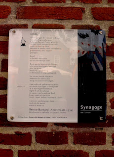


Barnard's complete text, refering to the fact that a local national-socialist used the complex as a depot for potatoes. David Colmer made the following English translation:


SHUL

On the wall of a former synagogue

Passer-by, this was a house of prayer
for nonzealous believers:
Salomon Samuel Frank, shopkeeper,
Nathan Jakob, of honest conduct,
name them. Here
they gathered: instructed
by forefathers, borne
by tradition.

Realise:
there is no such thing
as a former shul.

Think of the bastard who stored
his winter potatoes inside.
It is not nothingness
that terrifies
but its revelation in banality.

Even now, a cold millennium later,
an old man still stands
under the eternal lamp
mumbling in all his unshavenness
at the ark containing the names
of people death
scooped up like so many spuds:
Sam, Israel, Esther, Benjamin, Jakob.

You who are a passer-by,
as they were,
name them.


The newly formed square connecting the old and new shopping centres was called after Mozes de Hes (1864, Hoogeveen - 1942 Auschwitz), who was a religious teacher in Doetinchem, Smilde, Roermond, Gorredijk and Vlissingen. In 1926 he was appointed teacher and cantor in Bergen op Zoom. In 1942 he moved to Amsterdam. Shortly afterward, October 5th, he died in Auschwitz.


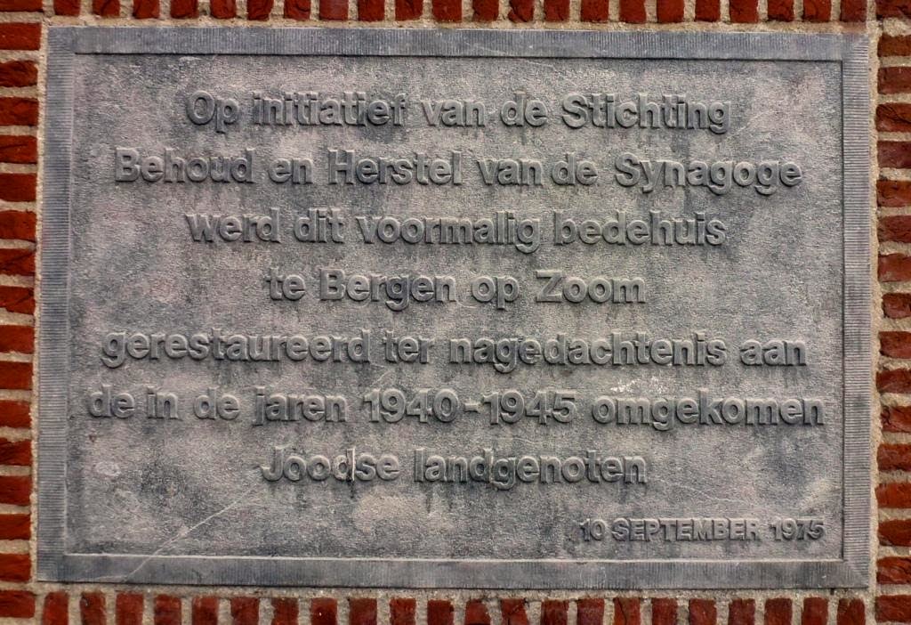
A plaque commemorating the opening of the restored synagogue by the ambassador of Israel in 1975. Between the end of the war and the early seventies, the building had fallen to ruin. Just before the remnants would be demolished in a slum clearance, the synagogue could be saved, thanks to the vigilance and perseverance of a small group of concerned residents.


The restoration works were also performed as a dedication to all the Jewish Dutch who didn't live to see the liberation. Few Jewish fellow townsmen returned to BoZ, too few to be able to reestablish the religious function of the building.


This sign explains that the synagogue was declared a national monument in 1975. Since 1996 the place is open to the public. On the first floor there is a exhibition. The new interior was, with much respect for the former functions, designed by artist Jan Wessendorp.


Many houses in the street were abandoned, due to their poor state after WW II. Since the eighties the downtown area has increasingly become a popular place to live in. Even on the Parade, a big square between Koevoetstraat and the main church, shops and apartments were built.


A new transom window in 'old style'.


All the shops, offices and apartments to the left are new, built between 2001 and 2006.


This double door is a design from the seventies.


After all the mistakes in favour of urban renewal during especially the sixties and seventies, most people in Bergen op Zoom realize it is essential to keep their town's heritage. In order to find a balance between old and new the town may not fossilize to become only a monumental area like some other historic 'fairy tale' towns. Since the centre has been classified as a protected area, new streets and constructions must however show respect to the environment, meaning for example that materials, size, colours and texture should fit. This process is continuously going on with ups and downs. The Parade-project, in which Koevoetstraat partially is situated, was designed by a group of international architects: Rob Krier / KCD, bOb Van Reeth / AWG, Sjoerd Soeters and Jan Weyts. Investors Rodamco and Vesteda made it possible to add 18.000 m2 retail space, 81 apartments and 2 parking garages with together 470 places to the town's functions and facilities. It helped Bergen op Zoom to be awarded Best Centre of The Netherlands in 2007, one year after completing the works. This corner is an example of mixing old and new elements.